
Starts and finishes at Elie Harbour
The following narrative is designed to help you find your way around the Elie Harbour area and provide some historical background on some of the interesting things that can be found. It can be used for a self-guided walking tour of the harbour area (other tours are also available on this website).
Start at Viewpoint next to the Sailing Club
The clubhouse was opened on 10th June 1995 and extended in 2000 to provide improved shower facilities. The club caters for both sailing and power boats with a healthy representation of both in the membership. The Sailing Club was actually formed in 1964 in the days when Elie had its own Town Council, which controlled and ran the harbour, the pier and its facilities along with the Granary building.
The harbour, which had existed for centuries, was at that time used by only a few pleasure craft and some local full-time fishermen. The number of pleasure craft was however increasing and a group of locally based and interested parties made an approach to the Council for the formation of a sailing club at Elie. The Council gave its blessing to the proposal and the first meeting of the “Elie Sailing Club” took place on 4th March 1964.
The Sailing Club was extended by the area with the bay window. Funds came from the sale of a model carronade which was sold at Christies for £18,000.
The full story – “ELIE SAILING CLUB – HOW IT ALL BEGAN!” by Tom Maccabe can be read by clicking HERE.
From the top of the Viewpoint, looking east from left to right, you will see Ruby Bay car park (unfortunately Fife Council used the name Ruby Bay for Wadehaven and would not change this although the error was pointed out by the Community Council. Ruby Bay actually lies between Lady’s Tower and the Lighthouse); Woodhav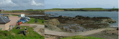 en/Wadehaven Bay (Blue Flag beach); the concrete blocks on the headland, which are the remnants of a network of anti-invasion obstacles erected by the Polish Army who were stationed all around the East Coast of Scotland during WW2 to defend against German invasion.
Lady’s Tower
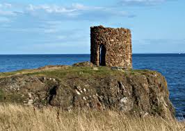 On the east side of Elie Ness, overlooking Ruby Bay, are the remains of the Lady’s Tower, the top of which can be seen. This was built in the 1770s as a changing room for the use of Lady Janet Anstruther of Elie House when she went swimming. When she wanted a dip she first sent a bell ringer around Elie to let the residents know they should keep away from Ruby Bay. As we understand it Jenny used the Tower as a viewpoint where she could sit to watch the world go by and recover from bathing/immersion. She changed in the man-made cave on the beach below the Tower. This was the same lady who had a whole settlement (Buchlyvie) moved to improve the view from her house, leading to a curse being placed on the family.
Ruby Bay is named after Elie Rubies, a type of garnet, which are sometimes found here.
Elie Ness Lighthouse
Engineer to the Commissioners of Northern Lighthouses at time of building was David Alan Stevenson,  grandson of the famous lighthouse engineer Robert Stevenson who gained this fame for the building of the Bell Rock Lighthouse lit in 1811. David Alan was a cousin of Robert Louis Stevenson. Work commenced in 1907 and the light was first lit for the mariner on 1 Oct 1908. Up until 1959, when the light was converted to mains electricity, it was powered by carbide and water generating acetylene gas and attended by HM Coastguard Elie.
The actual builder was Mr James Lawrie from Anstruther who was born on a troop transporter at sea coming back after the Crimean War. The light flashes white once every six seconds and is visible at a distance of 17 miles. During power cuts it has backup battery power. The lighthouse has recently been refurbished and now has the first LED (light emitting diode) lamp installed in a UK lighthouse. Responsibility for the lighthouse will pass from NLB to Forth Ports (the NLB (Northern Lighthouse Board) is the Lighthouse Authority for Scotland and the Isle of Man).
The Firth of Forth is some 55 miles in length, has a maximum width of 19 miles at its mouth and represents the most substantial estuary on the east coast of Scotland. The Firth can be said to begin at Stirling, its tidal limit. The main shipping lanes are on the south side, although some ships pass close to this coastline.
Bass Rock
The Bass Rock is situated in the Firth of Forth, two miles east of North Berwick and one mile off the mainland. It was used as a prison during Covenanters. You can read about conditions there in a book by James Robertson “The Fanatic”. The largest number of visitors to North Berwick fly in every year to set up home on the four offshore islands of Bass Rock, Craigleith, Lamb and Fidra. Around 100,000 sea birds nest on these islands with the largest colony on the Bass Rock, which has 80,000 occupied nest sites. The Bass Rock is the closest sea bird sanctuary to the mainland and was the first to be studied by ornithologists during the 19th century, when they gave the Gannet the scientific name Sula Bassana, incorporating the name of this rocky stack. This colony is the largest on the east coast of Britain and holds approximately 10% of the world population of North Atlantic Gannets.
North Berwick Law
Some hills have a presence and character out of all proportion to their physical size, and North Berwick Law is certainly one of them. Standing to a height of 613ft or 187m it lies immediately to the south of North Berwick, which at just seven miles distant from Elie and is the narrowest part of the Forth Estuary until the bridges are reached.
On a clear day you will also be able to see the Lammermuir and Pentland hills. The towns on south side of the Forth moving west from North Berwick you have Cockenzie, Prestonpans, Musselburgh, Portobello and Leith – the latter place from where steamers used to call into this harbour.
East Vows Beacon & Thill Rock Buoy
Engineer to the Northern Lighthouse Board at the time of building the beacon was Alan Stevenson son of Robert Stevenson (already mentioned) and uncle of Robert Louis Stevenson. The Beacon was built in 1847 and it and a buoy that then marked the Thill Rock became official navigational marks 1st Oct 1848. The Beacon was originally painted black then red and in the 1980s as it now stands as a South Cardinal Mark.
The port hand red light ‘can’ buoy that was in the Bay warning mariners of the dangers of the Thill Rock was permanently withdrawn by the NLV Pole Star on the 9th April 2008, a buoy had been on station there for 160 years, except for a period during WW2.
The Stevenson Family of Engineers built numerous lighthouse and harbours and was involved in many other engineering works at home and abroad. The family was involved with the Lighthouse Board for many generations.
[Much more information is contained in the book by Captain Alan Provan, ‘Navigational Aids at Elie & Earlsferry’ (Nov 07).]
Let’s move down onto the pier and have a look at the remains of the pier used by the steamers and we’ll tell you a bit more about Elie and Earlsferry and their harbours. Move to harbour wall and orientate yourself looking towards Chapel Green & Earlsferry so you can also see the remains of Apple Rock Pier on your left.
Apple Rock Pier
There was a ferry service between Elie and Leith twice a week and the daily Leith to Aberdeen ferry stopped here as well. Apple Rock Pier was used by paddle steamers on excursions or as regular ferries from late 1890s to mid-1920s to and from Leith, North Berwick, Dundee and other ports on the coast of the Forth. Most ferries went to the Chain Pier in Newhaven due to a dispute with the other harbours and ferry owners. There are several photos showing steamers on the pier and also the timetable and various adverts.

The photo above shows the paddle steamer Wemyss Castle at Apple Rock Pier Elie c1891 (built in 1872 for NB Steam Pkt Co Clyde services). Copyright Sandy Stevenson Tour Scotland.

Now look west across the bay towards Chapel Green and the remains of the hospice]
Earlsferry
What is now the village of Earlsferry came into importance in the mid-12th century when it became the landing place for pilgrims crossing the Firth of Forth on their way to St Andrews and beyond. You can see the remains of the hospice over on Chapel Green.
Although the story of Macduff’s escape is often credited with the reason for the village being so named, it was probably called the Earl’s ferry for the same reason as the crossing further up the Firth was called the Queen’s ferry – that is after the benefactor who donated the ferry. Queensferry, after the good and saintly Queen Margaret and Earlsferry after the Earl of Fife (Macduff). By then it had been an established ferry port for crossings to North Berwick for hundreds of years. It is said that MacDuff, the Earl of Fife, crossed from here in 1054 while fleeing from King Macbeth.
Of the two settlements, Earlsferry has the longer history, being made a Royal Burgh by Robert II in 1373. Most, if not all of the ancient Royal Burghs became so because of a connection with the pre- Reformation Church – in Earlsferry’s case the ferry from North Berwick which was run by the Cistercian Nuns there. Macduff not only owned land in Fife but also land around North Berwick, some of which he donated to the nuns. As the northern end of the link it is reasonable to surmise that, because of the huge number of pilgrims travelling, benefits would accrue to those helping them on their journey; pilgrims were the forerunners of the tourists of today.
In fact when you really think of it the Old Church organized and ran a very lucrative ‘pilgrim trade’ (much like the ‘tourist trade’ of today) – that benefitted not only those ‘in the know’ but all those around them! The destination of the pilgrims was the Shrine containing relics of St Andrew in the cathedral town of that name – St Andrews. In those days the fear of hell and damnation was very real. Pilgrimage, prayer, and donations (a ferry for instance) by those that could afford them, were all ways to avoid the deadly drop into hell! One has to remember that this movement of pilgrims was going on all over Europe, especially from the 12th to beginning of the 16th centuries when the influence of the Church was at its peak.
Earlsferry ceased to operate as a port after a serious storm in 1766. This drowned seven Earlsferry fishermen and completely filled the village harbour with blown sand. By this time Elie, which was much better protected from weather coming in from the east, had already become the more important of the two. The remains of the two Earlsferry harbours are still visible at low tide. (see Walk No 2 – Earlsferry by clicking this link.)
[Move along the pier to Millennium Beacon and orientate looking east into harbour area itself – the Beacon was one of many erected and lit as part of the Millennium celebrations ]
Elie Harbour
In 1850 Elie’s harbour was expanded, and a road was laid along the headland leading out to it from the village. Elie’s fortunes improved further in 1863 with the arrival of the railway from the main line at Thornton via Leven and Kilconquhar. The v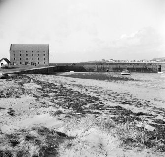 isitors brought by the trains were supplemented by those on board the regular steamers from North Berwick and Leith; suddenly Elie and Earlsferry became desirable destinations for Victorian trippers. The railway ran just to the north of the village but the original proposal was to route it along the coast next to the beach. The railway and the steamers have all long gone, but the villages remain significant centres for yachting and together serve as a local resort whose beaches are matched as attractions by the golf available on Earlsferry links. It was here that the famous golfer James Braid first played the game.
Elie grew up around the bay which provides a safe anchorage protected by an island with a causeway. It became a Burgh of Barony in 1589 under the Lairds of Ardross. As such Elie was forbidden to engage directly in foreign trade and was dependent on the Laird of Ardross who controlled the Town Council and Court. In the 1850s the harbour was improved and a road built on top of the causeway. Fishing and trading were carried from the harbour and goods were stored in the granary at the end of the pier. The granary, which lay derelict for many years, was recently restored and converted into flats.
The rock on which the granary now stands was formerly an island and could only be reached at near l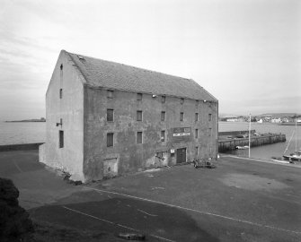 ow tide. In 1835 a group of gentlemen and farmers of the district invited engineer Robert Stevenson (yes him again) to survey the harbour which had been in a sorry state for many years. The plans produced were finally
implemented to some extent in 1853 when Sir William Baird (who made his fortune through coal, iron and steel at Gartsherrie near Airdrie) bought Elie Estate, also in 1853, and the present causeway, road and pier were completed within two years. Much of the traditional activity such as fishing and potato boats did not resume after the Great War.
When Sir Michael Nairn of Elie House died in 1955 his son, Michael George Nairn, gifted the harbour to the Town Council. In 1974 ownership was transferred to the non-profit making Elie Harbour Trust, who continue to be responsible for the harbour area.
 At low tide the award-winning beach at Elie Harbour links to Earlsferry, giving almost a mile of uninterrupted golden sand. With a wide range of facilities and activities available this is an ideal family venue. Facilities include toilets, lifeguards, first aid, disabled access and parking. Water sports are also available at this beach, which was again awarded Blue Flag status this year. The range of the tide at Elie is some six metres, or 20 feet in old money.
That s the end of the tour. If you want to take a short walk to the dunes next to the lifeguard’s hut you will get some more good views. There is a mooring post from the pre 1850 harbour still on site in the area where the boats are stored, which you might see when you pass – if you have sharp eyes!
The following is an excerpt from”The East Neuk of Fife” by Rev. W. Wood 1887 :
 “From the harbour to the Toft, there was formerly what was called a ‘swarf dyke’, along the west side of which the road ran. At that time the road was on the seaward side of the Toft gardens, and ascended to the street by a very steep incline…… This field had been swallowed up by the sea, and the ‘swar
f dyke’ also had given way and there was no passage dry-shod from the town to the harbour at full tide, when Mr Baird came into possession of Elie estates. Soon after, he rebuilt the pier, and lengthened it, and formed the present road, which is protected by two walls, the innermost of which is now completely buried in blown sand. “
[The “swarf dyke” can be seen in the painting on the cover of Archie Rennie’s book – The harbours of Elie bay – A History (right).]
